Sunday March 2nd – Weston Park, Sheffield – Gales again howled through the night but they are beginning to subside now. It is sunny as we visit Weston Park, a municipal park opposite Sheffield Children’s Hospital and next to the University of Sheffield library. It was the first municipal park in Sheffield. Originally Weston Hall stood here, a grand early 19th century house built for the saw-maker Thomas Harrison. After his death, the city council acquired the land in 1873 and Robert Marnock designed a park, one of most complete examples of his work. We visit at a less than optimum time as extensive restoration works are being undertaken. Most the monuments and statues are surrounded by fencing, paths are dug up and the lake is drained. The Weston Park Museum and Mappin Art Gallery are on the edge of the park in a large neo-Classical and Ionic order building finished in 1868 and opened in 1875. On the roof are models of Peregrine Falcons, attempts to keep pigeons away. The flock of feral pigeons fly down and land near us. Dill the Dog stands and stares at them, but cannot summon the energy to do anything about them. The pigeons seem to know this and strut around cockily. A few minutes after we move on a wee dog charges amongst them barking, scattering them immediately.
Tuesday 4th March – Bolsterstone – We take a short walk along the Trans-Pennine Trail on the old Sheffield-Manchester line at Fingle Street. Dill the Dog follows gamely, but makes it clear she  would rather just stand and sniff. We then head up to Bolsterstone. I visited in January 2007 and some details can be found in that entry. However, the church is open and we enter. Inside it is a typical mid-Victorian church. On the west walls are black wooden panels on which the Ten Commandments, Lord’s Prayer and the Creed are inscribed in gold lettering. These would originally have been hung either side of the altar. A stone ball is a relic of the church built in 1791 by the Revd Thomas Brand. Here also is an elaborately carved black chair. Until 1967 it served as the Bishop’s Chair for confirmations. It is only known as a gift from Holy Trinity Church in the Wicker in Sheffield from 1895. In the centre of the back is an ornate carving of a Green Man. A window in the north transept is a 1997 stained glass window, a tribute to The Bolsterstone Male Voice Choir, a famous choir that has won a number of national and international honours. Above the chancel is the Royal Arms that would have been positioned above the pulpit. On the pillars of the nave are the carved heads of the six priests who were incumbents between 1777-1879. The name Bolsterstone has several theories. Firstly there is “Balder’s” dwelling or farm. Balder is the name of a Norse god, or may be a corruption of Walder, the local Anglo-Saxon chief. Alternatively, there is the presence in the churchyard of the Bolsterstones, two large stones. Canon Wilson transferred these from the village green at the beginning of the 20th century. They were thought to be stones of a mediaeval torture instrument used to execute criminals. Wilson, however, puts forward the suggestion that one could be the horizontal member
  of a stone trabeate structure such as those at Stonehenge. Wilson added that the upper stone was recorded to have six crosses carved into it, still visible in 1750 and he considered these to be the Christianisation of a pagan object. However, 19th century historian Wallace Charlesworth believed the stones were originally located at Unsliven Bridge. He hypothesised “Unsliven Bridge” is a corruption of “Unshriven Bridge” where those accepting baptism entered the water to emerge on the opposite bank in Anglo-Saxon times. The stones were moved to the village in July 1796 when the bridge was widened. (My thanks to a booklet by Pamela Crossland BA for the above information.) We wander through the graveyard and notice there is another large graveyard beyond the walls. Through slushy snow and down a track between the graveyards. A cock Ring-necked Pheasant wanders along the road but then decides we are getting too close and leaps up and over the garden wall of a large Victorian House. Across from the church are two cottages called “Castle Cottages”. The pub is called The Castle. It is thought the castle was a manor house, possibly fortified in mediaeval times.
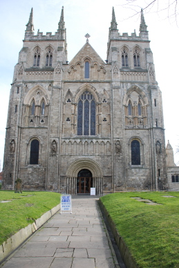
Wednesday 5th March – Selby – A market town in North Yorkshire, although historically it was in the West Riding. The name comes from Sele – Saxon for a Willow Copse, many of which grow along the River Ouse, and -by – Viking for a town. A small Anglo-Saxon settlement was in the district before the Conquest, but it is after the Normans arrived that Selby was really founded around a monastery. The story is that a monk, Benedict or Benoir of Auxerre Abbey in France had a vision in which St Germain to him to go to Selby and build an abbey. Germaine was a French nobleman and soldier born in 378CE. He became a Christian and was nominated as Bishop of Auxerre. He visited England twice but died shortly after his second visit in 448CE. His shrine in Auxerre became a site of pilgrimage. It is also said that Queen Matilda gave birth to Henry, William’s youngest son at Selby in 1068. In 1069, Benedict arrived and saw three swans alight on the river which was part of his vision so he knew he had found the right site. He set up a cross beneath a giant Oak called Strihac. When William heard of this event, he shrewdly realised that after the Harrowing of the North, he could be seen in a favourable light by founding an abbey in the north, so he grated Benedict a charter giving him the land in Selby and other sites to support an abbey. A wooden abbey was constructed and the Archbishop of York ordained Benedict as the first Abbot of Selby. Hugh, the second Abbot, started building a stone church near to the site of the original and this building continued to develop into the 15th century. Many of the extensive buildings associated with the monastery were taken and demolished or fell into ruin after the Reformation. The abbey itself became the parish church. Sir George Gilbert Scott carried out a major renovation of what was then a pretty ruinous building in 1871. In 1906 there was a major fire which caused much damage.
We approached the via the main shopping street which runs toward the building before veering right around the market place and abbey. A very worn market cross stands in the market place, which today is hosting the monthly Farmers’ Market. The front of the abbey has a magnificent Norman doorway and pinnacles which were
Near to this Stone lies Archer (Iohn)
Late Saxton (I aver)
Who without Tears thirty four years,
Did Carcases inter,
But Death at last for his works past,
Unto him thus did say,
Leave off thy Trade be not afraid,
But forthwith come away;
Without reply or asking why,
The summons he obey’d,
In seventeen hundred and sixty eight
Resign’d his Life and Spade.
Died Sept 15th AE 74
added in 1935. Four statues look down, these also a relatively modern. The nave is lined with large round pillars, one is decorated with a diamond pattern and named after Abbot Hugh. Some of the arches at the eastern end are deformed by the foundations sinking early in the abbey’s history. A pair of old, worn tombs lie in the nave, that of Hugh de Pickworth and his wife Margery. Hugh fought for Edward II  in Scotland and served in Parliament. Golden roof bosses look down, including a Green Man. The screen, which separates the nave from the chancel is an ornate wooden structure. It was originally further into the nave. On the south aisle of the nave is a plaque to John Archer (see side box) In the north aisle are a number of ornate capitals, one is a complex of leaves and when a torch light is shone into the interior a mask of Edward VI. Here also is a “Leper Squint” to enable people to see the altar from the north transept. From here, one can look up above the chancel at the “Washington Window”. The window, with glass from the 14th century, contains the heraldic arms of the Washington family, described as “Argent, two bars and in chief three mullets pierced, gules” The “mullets” are stars and the first President of the United States, George Washington, used these arms as the basis of the Stars and Stripes. The window probably represents some kind of benefaction made to the Abbey to commemorate John Wessington, Prior of Durham (1416-1446) the most distinguished collateral ancestor of George Washington. The high altar is a replacement for the one destroyed in the 1906 fire. Unfortunately, it has been built so high that it obscures the lower parts of the magnificent east window. Back through the main street it is sad to see the “Local Board Offices” are now a closed pub. Finkle Street leads down to a large square where stands the Post Office. Finkle Street does have a bend in it (see earlier discussions on the origin of the name). Selby also had a proud history as a port and site of ship building, although this trade has almost disappeared now. A trawler, “Grampian Fame”, was built here in 1957. It is now well known as the Greenpeace flagship “Rainbow Warrior II”.
Friday 7th March – Dearne Valley – Down Willowbank where small but fat leaf buds cover the Hawthorns. A pink-breasted Chaffinch pours out his song from a low branch. Pussy Willow is emerging in small grey furry buds. Down in the valley, the rough meadow is covered by Hawthorns bushes. These are about ten years old; very few were here when I first walked these grasslands. A small flock of Redwings fly through the bushes. They disappear into the depths of a bush, then one emerges to feed on the ground, chasing off a Blackbird. A pair of noisy Mallard fly up the valley, followed a few minutes later by a silent flock of about a dozen more. A Grey Heron flies low across the valley. An old part of the river curves round behind where I am sitting on a fallen log. Various mutterings and rustlings of Moorhens come from the reeds. The water in this long, thin pond is crystal clear, rippled by the strong westerly wind. I cross the valley, over the stream that runs down from the marsh area and over to where the Loop was cut off from the present course of the Dearne. The raised banks of the old river route can be seen meandering across the meadow. A footpath runs alongside the river, one oddly I have never followed before. It leads along between the Loop and river. The Loop area is quite extensive these days. A pair of Tufted Duck, Teal and Moorhens are in residence. Over the river is a large field of winter grain. A Skylark sings high above it.
A Snipe flies down the valley. The area between the river and Loop is still a mess of dried mud and dead plants from last year’s flooding. New plant life is just beginning to peep through. Down further where the Loop flows back into the river the area is one of devastation. Mud covered logs and rubbish is strew everywhere. Whole trees lie in the river. It will take another flood to clear this away. A path leads back up to the canal tow-path. Goldfinches flash in the trees. The field near Gypsy Pond is flooded. Several Black-headed Gulls are feeding, their heads ranging from the white winter plumage to a full black head of the summer plumage. Over Smithies Lane and down beside Fleets Dam. All the birds have been blown down to the south end by the wind. Several dozen Black-headed Gulls float on the water, rising to squabble and then tour the water. Six Great Crested Grebe are together, although one individual, the only one still in winter plumage, seems intimidated by the others. A pair of Mallard drift across the water. Down the river to the weir where a Wood Pigeon flies past with nesting material in its beak. Over Old Mill Lane. Earth-movers have flattened the old gas works site. I do not know what they are planning to build here. I hope they remember it flooded last year! A path follows the old railway line down into Dearne Valley Park. Here the paths have been filled with white chippings after they were deeply gouged by the floods. A great trunk remains jammed in the fork of a willow.
Bradford – In the evening, a group of us go in Dave’s Bongo to Anams restaurant in Bradford. Inside it is extraordinary. The ceiling is covered by what looks like a huge Tiffany lamp. At the far end is a raised stage containing a chaise longue and a couple of chairs all matching the surrounding drapes in a pale peach colour. Running the length of the restaurant is a long pond containing Koi Carp and what look like Sturgeon. The restaurant is a buffet service and the food is sublime. As we leave a group are feeding the fish with small pieces of naan bread.
Saturday 8th March – Barnsley – The town is buzzing with excitement as Barnsley Football Club take on the mighty Chelsea in the F.A. Cup. It is said that a single
First frog spawn dates
2001 - 12 March
2002 - 18 March
2003 - 12 March
2004 - 16 March
2005 - 17 March
2006 - 23 March
2007 - 12 March
2008 - 9 March
Chelsea player would command a greater fee than the whole Barnsley team. But at the end of the match, how the mighty have fallen – beaten 1-0 by the Reds!
Sunday 9th March – Home – It is a bright morning but clouds are moving in fast. A Robin is singing in the cherry tree. Large globs of frogs’ spawn have appeared in the ponds. The side box shows that despite so many reports of climate change bringing events forward each year, in this case there is little meaningful change in date. A Great Spotted Woodpecker is drumming in the trees at the bottom of the garden.
Brightside, Sheffield – From Meadowhall a track leads down towards the city, separated from the River Don by a high bank. Goldfinches flit through the trees on the bank. A Wren darts into the undergrowth. The track joins Weedon Street and heads west back towards the river. Tall willows are yellow with pollen laden pussy-willow. The road crosses the river; just upstream the railway also crosses. The Five Weirs walk, part of the Trans-Pennine Trail, heads upstream towards the city centre. Flood debris is everywhere around the river  banks. Old walls, culverts and concrete constructions for purposes forgotten line the river banks. A brick monument and sculpture attempts to make an office park on the opposite side of the river look interesting, but fails – although I discover later that it is rather more interesting than it seems from here. One of the weirs stretches across the river. Its top lip is choked with wood, trees and bushes washed down stream, awaiting the next flood to move them on. This is Brightside Weir and the path is “Weir Head”, a part of the river walkway pre-dating the Enclosure Acts of the 18th and 19th centuries. Brightside Weir is the largest of the five weirs on the river. It has been here since 1328 at least, when Thomas de Furnival, Lord of Sheffield Manor, had a corn mill just opposite. In the 18th century, the Booth family had built forges here which were sold to William Jessop and Sons in the 1840s. William’s son Thomas greatly expanded the business, with a considerable trade to America, and by 1875 the site employed over one thousand people. Thomas Jessop gave money to buy land and build the women’s hospital that still bears his name. Opposite a crane has an electro-magnetic attachment and is lifting and dropping a huge steel ball onto something that is hidden behind the fences.
The trail  moves away from the river at this point to skirt around the huge forges and rolling mills of Sheffield Forgemasters. Over the way stands a pub called Carbrook Hall. This is a wing dating from the 1620s of the hall. Originally built around 1176, it was the home of the Blunt family. The hall was rebuilt in 1462 and bought by Thomas Bright, Lord of The Manor of Eccleshall in the late 16th century. His descendant, John Bright, was a Parliamentarian in the Civil War and the hall was used as a Roundhead base during the siege of Sheffield Castle. Apart from the present pub, the rest of the building was demolished in the 19th century. It is reputed to be the most haunted building in Sheffield, prompting a nearby establishment to long have a sign stating “We have no ghosts but our spirits are cheaper”. Down the road towards Attercliffe is the entrance to steel mills. A fine Victorian pub stands by the entrance, Wentworth House Hotel, an isolated remnant of the large community of steel workers whose homes have been replaced by offices. My road turns off towards the river. Looking over the wall there is a cobbled way running between two large steel works buildings. Railway tracks run down this roadway and off towards a railway bridge over the river. All these tracks are now disused. The river here runs between concrete walls and banks. Round into Brightside Lane where the tall
 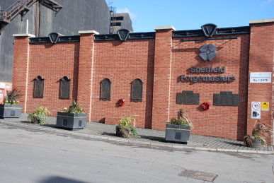 steelworks tower like cliff-sides over the road. By an entrance is a wall attached to which are brass panels commemorating the war dead of steel workers – over 70 in the Second World War and over 300 in the First World War. Many of the building here are empty.
The Vickers Building is a massive four storey block of offices with a black marble entrance way containing huge brass doors. It was built in 1907 as the head office of the steel, engineering and munitions giant Vickers. English Steel, British Steel and Sheffield Forgemasters all occupied the building but it is now empty, a great anachronism now to an industry that is a shadow of its former importance to Sheffield. Further up the street is the office estate I had seen from the other side of the Don. The brick arch has been rebuilt here having been the entrance to the Brightside Steelworks of William Jessop and Sons that stood on the spot from the mid 19th century until the late 20th century. The arch is the only remaining piece of the huge works. Timbers have been found from huge tilt hammers which had been dumped in a pond when the site was modernised in the 20th century. Tree-ring dating has placed them from 1715 to 1880. On up the road, small cobbled streets lead off to nowhere. The pub looks run-down, it may even be closed down. Everywhere are modern estates of offices, until I again reach the temple of consumerism, Meadowhall. Back up the motorway, near Hood Hill, a pair of Carrion Crows are harassing a Common Buzzard.
Monday 10th March – Burton Bank – Storms are lashing the south-west of the country and heading this direction. Last night the air pressure had fallen to 990 mBars, it is now 965 mBars and still falling. Wind and rain beat against the house in the night, but this morning it was bright and sunny. Burton Bank is a long hillside to the north-west of the town centre. The top contains the remains of old quarries. Below is the valley of the River Dearne then the land rises up to the Town Hall. As I have mentioned before, the top of the hill should have the Town Hall and St Mary’s Church as the outstanding features but they are obscured by modern “boxes”. There is little bird song up here. A Sparrowhawk flies along the hillside then over Old Mill, rising on a thermal, higher and higher, circling slowly.
Home – By midday the sky has clouded over. The barometer reading is now 963 mBars. By nightfall the wind has risen again and it starts raining.

Tuesday 11th March – Wentworth – Taking advantage of a lull between the storms sweeping through in waves, we head to Wentworth. A public footpath leads into the estate of Wentworth Woodhouse. To both sides are the abandoned buildings of what was The Lady Mabel College of Physical Education, established in 1949 to train women physical education teachers. The college merged with Sheffield Polytechnic but was closed in 1988. A vast building looks at first like a fine house but is the stable block. Built in 1768 by John Carr, there is a large fountain, now disused. Pevsner reports: “...the stables comprise 15 bays with a rusticated entrance with Tuscan columns, pediment and cupola.” The path runs gently down the hill. In the distance the Rockingham Mausoleum stands black and foreboding. Peacocks can be heard shrieking beyond the trees on the right. Jackdaws call from the tree tops. Suddenly, the trees are gone and the vast façade of Wentworth Woodhouse is revealed, at over 600 feet, the longest façade in England . The house is actually two houses back to back. The Western House was started in 1725 by Thomas Watson-Wentworth (1693-1750, later Earl of Malton and Marquis of Rockingham) on the site of a Jacobean house built by Thomas Wentworth, 1st Earl of Strafford.  The West Front or “Back Front”, as it is locally known is built largely in brick with Baroque stone facings. It cannot be seen now. It appears that a family feud with the Stainborough branch of the family resulted in the building of the Palladian East Front. Thomas Wentworth, Lord Raby and later Viscount Wentworth and Earl of Strafford had been bitter that the Wentworth Woodhouse estate had passed to the Watsons and not to his family
  and built Stainborough (Wentworth Castle) as a sort of revenge. Thomas Watson-Wentworth was dissatisfied with the West Front, probably because of the magnificence of Stainborough and commissioned Henry Flitcroft to start on the East Front in 1734. An extra storey was added to the wings around 1782, possibly when the 2nd Marquess, Charles Watson-Wentworth died only 14 weeks after being appointed Prime Minister for a second time and the estate passed to the Fitzwilliam family. In 1790 they employed Humphrey Repton to create the parkland. In 1946 much of the park in front of the house became an opencast coal mine on the orders of Manny Shinwell. Some say the coal was very poor quality and the mining was ordered as an attack on “the privileged rich”, an accusation always denied by Shinwell. The gardens have never been fully restored after mining ceased. An area in front of the house is a police dog training area – one way of deterring trespassers! The house still remains in private hands and very few have seen the interior. From in front of the house, as near as one can get on the public footpath, Keppler’s Column stands to the south and Hoober Stand peeps over the hill to the north-east.
Friday 14th March – Newsome – A suburb of Huddersfield, Newsome sits on the slope down down from Castle Hill and up from the valley of the River Holme. The train station is at Berry Brow. From here I head past a Victorian school building, still being used as a junior school, and across to Lady House Lane. The road climbs steeply, past Victorian and more modern houses. A footpath is more like a small stream as water pours down and then down the road. The road winds and flattens for a while, overlooked by Castle Hill. A steep sided little wooded gorge runs down the hill, water pouring from a pipe deep  under the road, yellow daffodils gaily enlivening the dark banks. The road enters Hall Bower, a small hamlet. A family called Beaumont lived hereabouts in the 15th century. They were involved in the “Hall Bower Murders”. The War of the Roses had started in 1455, a struggle between the Houses of York and Lancaster. In 1471, two groups, the Beaumonts, led by Nicholas Beaumont and the Kayes, led by John Kaye of Woodsome were involved in a fight. The Kayes were originally from Oldham in Lancashire, so it has been suggested this incident was part of the Wars of the Roses, but it is more likely this was two powerful families in a dispute over money. Nicholas and John Beaumont and one of Kaye’s men, Thomas Adderley were killed. The only outcome was that the Kayes were ordered to pay the Beaumont widows, both called Jane, the sum of £44 in compensation. The Beaumonts lived in the Hall that gave the village its name, Hallboure, but after the fight, it passed to the Lockwood family and then the Blackburns, who were clothiers. The villagers would have been spinners and weavers, their cloth traded by the Blackburns. After the Industrial Revolution, life changed and the workers would have to have walked down the hill to the mills built in the valley. The Hall changed hands several more times and was demolished in the latter part of the 19th century. Why it was taken down and indeed exactly where it stood are unknown. The village workingman’s club is an old building, but a good number of the houses are modern. A path leads off the road straight up to Castle Hill End, a small row of cottages right under the castle. The slope is wet and slippery. A fairly substantial track once lay here, remains in the shape of edging stones and gravel can be seen in places, but it has mainly disappeared under large Holly bushes.
At the top, steps lead up from the road to the Victoria Tower, built in 1897 to celebrate the Queen’s Jubilee. The hill itself is an outcrop of hard Grenoside sandstone surrounded by softer shales and coal seams. Mesolithic and Neolithic man would have  known the hill as trade routes ran through the valleys. An Iron Age hillfort was first constructed around 555BCE and its defences were strengthened after the Roman Invasion. After the Norman Conquest, the area round Almondbury, the village down the road, was part of the Honour of Pontefract and held by the de Laci family. They built a castle here which is mentioned in a charter from King Stephen to Henry de Laci dated around 1145. In the early 14th century a village was laid out on the hill although it was probably abandoned by 1340. After that the hill was unoccupied and used as a beacon point and also popular for rallies by such as the Chartists and during the Great Weaver’s Strike of 1883, several thousand people braved the cold to listen to their union leaders on the hilltop. Gorse bushes are in flower around the hillsides, bright yellow jewels in the dark green vegetation. A Robin sings continuously from the top of one of these
bushes. Blackbirds dart through the scrubby trees. Clouds of gnats hover by the bushes. There are ditches, dykes and banks surrounding the hilltop, mediaeval in origin, none of the Iron Age fort remains. A well stands in one corner. Below is a long white cottage seemingly of some age, referred to on the old maps as “Lisbon”. The view looks out for miles across a patchwork of stone wall defined fields and wooded hills.
known the hill as trade routes ran through the valleys. An Iron Age hillfort was first constructed around 555BCE and its defences were strengthened after the Roman Invasion. After the Norman Conquest, the area round Almondbury, the village down the road, was part of the Honour of Pontefract and held by the de Laci family. They built a castle here which is mentioned in a charter from King Stephen to Henry de Laci dated around 1145. In the early 14th century a village was laid out on the hill although it was probably abandoned by 1340. After that the hill was unoccupied and used as a beacon point and also popular for rallies by such as the Chartists and during the Great Weaver’s Strike of 1883, several thousand people braved the cold to listen to their union leaders on the hilltop. Gorse bushes are in flower around the hillsides, bright yellow jewels in the dark green vegetation. A Robin sings continuously from the top of one of these
bushes. Blackbirds dart through the scrubby trees. Clouds of gnats hover by the bushes. There are ditches, dykes and banks surrounding the hilltop, mediaeval in origin, none of the Iron Age fort remains. A well stands in one corner. Below is a long white cottage seemingly of some age, referred to on the old maps as “Lisbon”. The view looks out for miles across a patchwork of stone wall defined fields and wooded hills.
A large car park has been constructed where there used to be a pub. I am a bit disorientated, because the pub was here when I last visited, but apparently the owners tried to enlarge it in contravention of planning  permission and after a long legal fight it was wholly demolished last year. From this side there is a view right across Huddersfield to the Pennines beyond. A road leads back down the hill, skirting the edge of Hall Bower. A school was rebuilt here in 1879, now the Sunday School. Opposite is a splendid circular house built in 1995, one of the only decent modern buildings in the district. Down Jackroyd Lane there is a mixture of late Victorian, Edwardian, art Deco and post-war houses. All pre-war properties have a flair and sense of proportion that is simply missing in the later buildings. The streets contain a good number of direction signs for walkers. The road enters the centre of Newsome. On the crossroads stands the church of St John, mid-Victorian I would guess. In Towngate a public fountain was built in 1844 to provide a reliable supply of water for the local people. The nearby pub is called “The Fountain” and is a fine establishment – stone floors, tables made from old Single treadle sewing machines and an excellent pint of Black Sheep Bitter for only £1.90!
Monday 17th March – Willowbank – A Greenfinch is wheezing his song continuously from the top of a tall Ash sapling near the top of Willowbank. The day has a bright greyness about it – dawn was clear and the sun rose brightly, but then it clouded over although the cover was not thick enough to cut out the brightness behind it. Moving down the hillside reveals that the Greenfinch was a bit of a loner; there are hardly any birds singing at all. The main sound is the clanking of machinery over the river in the Council yard. A pair of Mallard are on the canal below me. I head into the Hawthorn thickets that surround the old shaft heads. Blue, Great and Long-tailed Tits are all calling, but in a subdued and fragmentary manner. Down by the canal, Moorhens can be heard chipping from the Loop. The whole area is disgracefully filthy. It is hard to understand the mentality of people bring Asda trolleys at least a mile from the store to dump them over the canal bridge. Other half-wits have dumped dustbin bags of rubbish on the banks, which have split and spilt household waste everywhere – it must be further to carry these bags from a car than it is to the council dump-it site. Plastic bags are everywhere. Back along the other side of the canal. A Blackbird is feeding on Ivy berries. Many more Blackbirds are on the hillside. A Song Thrush is searching the ground that has been churned up by horses hooves. A Jay slips away over the top of the hillside.
Worsbrough – Worsbrough is an old settlement, variously named as Wircesburgh, Wyrkesburgh or Wirkesburgh over the years. In the days of Edward the Confessor, in the years just before the Norman Conquest, it was recorded that the land was held by Gernber and Haldene, having 5½ carucates “about 100 acres” with 4 ploughs and valued at £4.From St Mary’s Church, the road leads down past a vicarage, which although stone built looks modern and indeed is not shown on the 1931 map. There are more modern houses and a path leads off down the hill towards what was in Victorian times, Worsbrough Park Colliery which became part of the large Barrow Colliery, now all gone. The colliery was named Barrow because the men who sank the shafts hailed from Barrow-in-Furnace. There was a great tragedy at the pit on 15th November 1907 who 7 men were thrown from the pit cage and plunged 200 feet to their deaths down the shaft. The church dates from the 12th century and is locked. It is surrounded by the graveyard which was extended in 1826. Oddly, there is a piece of an old archway resting on the ground. A number of gravestones give the occupations of the deceased, including William Shaw of Worsbrough Mill – presumably the miller; John Green of King Well; a bleacher, John Harrison of Worsbrough Dale, a tailor; Matthew Ogden of Bird-Well, a besom maker and Joseph Beaumont of Worsboro-Bridge, a Colliery Manager “who met with a sudden death by an explosion of fire damp in Pilley Ironstone Pit, September 16th 1845”. The grave of the Clerk of the Chapel called Wildsmith is dated 1800. A Dame Wildsmith was known to keep an inn by the sign of the Bluebell nearby and there is a modern sign in the village requiring people to keep dogs off the playing field, signed by A. Wildsmith – a  truly local family. There are also graves of the Biggins of Houndhill, a house built by the Elmhirsts, who relinquished it in 1683 before reacquiring it in the 1930s. Another grave refers to John Shaw of Houndhill, Gent. Another grave names John Cawood of Robroyd, a house on the hillside opposite Stainborough. John Cawood had married Ann, daughter of William Elmhirst of Ouselthwaite Hall. A grave of 1842 records Firth of Robroyd. A pair of Mistle Thrushes fly up into a tree in the graveyard. The tree has lost a large limb and the resultant stump is rotting away. A Robin disappears into the hole in the stump. A Blackbird slips through the cast iron railings surrounding a tomb, its orange bill shining against the grey stone and dark green Ivy.
The village hall dating from 1560, once the Grammar School, stands next to the church. A doorway leads off the graveyard into a delightfully peaceful garden of remembrance, a small lawn, borders and a couple of benches all overshadowed by a large Yew tree. Nearby Park House, named after the area to the north of the village, formally Worsbrough Park, now fields, has a bell inset into the gable end. Worbrough Hall is an Elizabethan house home in the early 17th century of the Edmunds family, whose name lives on in the village pub, The Edmunds Arms. The house passed through a number of owners, in the 20th century the National Coal Board had it as offices and is now back in private hands. It requires much renovation and is covered in scaffolding and new walls are being constructed along the roadside. A path  crosses fields towards Worsbrough Reservoir. Rooks have built a rookery in the trees lining the A61 Sheffield Road, Bell Bank Wood. Over this road, which was built following an Act of Parliament in 1840, and down a track that then runs across the River Dove where it enters the reservoir. A Blackthorn is in flower by the track. Down by the Dove, the banks are covered in Wild Garlic, Ransoms. Black-spotted dark green arrows of leaves of the Cuckoo Pint line the track. I used to refer to the this track as the cross lane as it joined the two paths that ran either side the length of the reservoir, from the old maps it is named Doe Lane and leads to Bridle Road which then turns south down to Rockley Old Hall. This was the seat of the elder branch of the Rockley family from the Conquest to 1280 when it passed by marriage to John de Everingham of Stainborough, much to the anger of the younger branch of the Rockleys who lived at Rockley Abbey. The hall was sold to William Walker in 1573 and the again to Geoge Milner in the late 17th century, passing by marriage to General Spencer in 1800. This fine Elizabethan house has been much rebuilt and modified over the centuries and it and the outbuildings are all converted into dwellings and cannot be visited. Past the Hall and down to a path that lead round to an old Willow carr beside the M1 motorway which roars away above me. The path crosses a culvert which brings the river under the motorway and then turns up into Saville Spring, a woodland of Oak and pine. This rise steeply back up to the Sheffield Road at Balk Lane and through the post-war semis and bungalows to Worsbrough Village again.
Tuesday 18th March – Armley Mills, Leeds – The mills now house the Leeds Industrial Museum, one of the best museums we have visited for a long time. The mills stand on the River Aire and the Leeds and Liverpool Canal. The first mills here were built in the 16th century for “fulling” – pounding cloth with water and “fullers earth” to make felt. In 1788 there were five waterwheels and 18 fulling stocks. They were bought by Colonel Thomas Lloyd who turned them into the largest woollen mills in the world. Lloyd was with the Leeds Volunteer Infantry of whom wags said, “They saw action at social functions, fighting fires and intimidating disgruntled industrial workers”. In 1804 the mills were bought by Benjamin Gott, but burned down in November of that year. Gott rebuilt the mills in brick and iron and it is these building that survive today. The museum covers a wide spectrum of Leeds’ industry. Spinning mules and looms remain in place after the mills closed in 1969. They should be demonstrated but we are told that there are few people who know their mechanical intricacies and they now need maintenance. Other rooms are dedicated to Leeds pioneering work in cinematography, printing, tailoring, engineering and engine making. There are numerous exhibits of machinery, large and small that drove the industrial north of England, now virtually all gone.
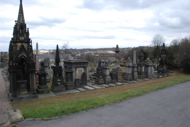
Undercliffe Cemetery, Bradford – This is one of the great Victorian cemeteries of England. The sheer scale of the monuments tends towards hubris rather than remembrance of the dead. Columns point skywards, seemingly in competition with each other as to who can point closest to God. Miniature temples abound, one, the Illingworths, is an Egyptian temple  complete with sphinxes. Another has a full sized sleeping mother and child on the lid of the tomb. Another a large alcove with the statue of a grieving woman. All manner of employment is recorded from plumbers, fishmongers, merchants to vicars, archdeacons and Members of Parliament. A simple stone records one of the latter, Bob Cryer who died in 1994, described as “A Socialist Parliamentarian, Iconoclast and Life-Long Rebel” – a hero to those of us who have never accepted “New” Labour. Much more about this extraordinary cemetery can be found here.
Good Friday 21st March – Stocksmoor-New Mill – Take the train to Stocksmoor. Every time I ride on the Barnsley-Huddersfield line I am reminded of the huge amount of effort and the millions of tons of rock that was removed to make the deep cuttings and tunnels through which the railway runs. From Stocksmoor station I walk up the inevitably named, Station Road. The housing is mainly mid to late 20th century with the odd Victorian villa. At Cross Lane the road becomes Fulstone Road. At the junction are a row of troughs, two sealed and one marked 1875. Opposite stands a Victorian house called “The Wells”. On up the road and past a new development made to look like an estate of barn conversions – rather weird but at least not the normal boring modern housing. The road is lined with Sloe bushes on the verge of blooming. Sloe or Blackthorn flowers before the leaves emerge and the success of sloe crop is a risky business. Today is chilly and very  windy again so the pollinating insects are unlikely to be flying. Across the fields stands a pleasant row of old houses at Stocks Moor Top. A right turn leads up Stocks Lane. Celandines are in flower. A small group of houses named after fruits with the word farm added lies on a bend in the road. Originally it would have been a single farm, Stocks Farm. Carrion Crows search the fields for food, each with their own large space unlike Rooks. Across the fields, in the distance is the folly, Black Dick’s Tower. Past the junction of Ing Head Lane.
Lower Halstead Farm is a considerable size. A pair of young beef heifers stands in the yard. On up the road there is a flock of Fieldfares spaced across a field. The junction with Haw Cliff Lane is at Upper Halstead and Stocks Lane now becomes Halstead Lane. According to the old maps, the houses here are Upper Halstead and Belfast. Sky Larks are singing. The views across valley are splendid. The lane starts to drop, steeply by Hanging Royd Shrogg. Now I lost the map of the area some weeks ago and, because we are supposed to be moving away very soon, I have not replaced it. Thus I am not sure exactly where I am heading. The road keeps dropping past large houses, Old Biggin Farm, New Biggin Farm, Hill Top where there was a sandstone quarry and Carr Gate, once the entrance to a coal pit. Below through the trees of Kaye Wood there is a village. The lower I get the larger the village becomes. Eventually the penny drops, it is New Mill. For some reason I am surprised, but I really ought to know the layout of the land here. The road is now Cold Hill Lane and enters New Mill just before the main junction of the Huddersfield to Sheffield and Barnsley to Holmfirth roads. I think a bit and decide to head up Sude Hill, past some delightful weavers’ cottage and the  Victorian church.
A lane leads off, Fulstone Hall Lane. As the road out of Stocksmoor was Fulstone Lane, I take this as a good omen. It is 11:40 and the church bells are tolling. From the edge of the village, looking back there is a number of corvids circling on the warmer up-currents of air over the village centre. A Sparrowhawk drifts across the valley. The lane passes Fulstone Hall, originally Foolstone, a collection of converted farm buildings and a large farm house. Coltsfoot is in flower on the verge. As the lane enters the small hamlet of Fulstone a pair of goats are feeding on the hillside. Both have very long silky hair, one shades of gold, brown and white and the other black with just a few highlights of brown. Across the field, rabbits are feeding. A road junction, White Ley Bank and my route becomes Far Well Lane. The road drops steadily. The walls are thin laminae of stone with moss and lichen on the top. A Weasel darts across the road, leaping high onto the verge. At the foot of the valley at Ellen Spring, a pair of streams join. The road rises again and becomes Fulstone Lane as it re-enters Stocksmoor. A house, probably erected in the mid 20th century, has a stone incorporated into the garden wall reading, “Erected by Walker Hellewell 1871” – no explanation. I was going to head on past the  station to Thunderbridge, but the sky is darkening and it is threatening rain, so a couple of pints in The Clothiers Arms seems a better choice.
Easter Sunday 23rd March – Home – Intermittent snow fell yesterday, some quite heavy flurries. It has snowed again overnight but there is not a serious covering. It certainly has not deterred the local Great Spotted Woodpecker that is drumming in the trees at the bottom of the garden. By mid-morning, the sun shines brightly and a rapid thaw is under way.
Easter Monday 24th March – Gawber – The village of Gawber was a small settlement between Barnsley and Darton. Nowadays it seems to cover everywhere along the Huddersfield and Gawber Roads out of Barnsley – indeed our own address is sometimes referred to as Gawber. According to The Oxford Dictionary of English Place-names, there is a reference to Galghbergh in 1304, from the Old English galga or Old Scandinavian galgi meaning “gallows” and beorg, again from both roots meaning hill – hence “Gallows Hill”. However, I have no further knowledge regarding the whereabouts of said gallows. We set out from home and head up to the junction of Gawber Road, Pogmoor Road and Greenfoot Lane. In recent years, there were three general stores in the region of the top of Greenfoot Lane, now one is a sandwich shop, one a private residence and the third closed down. On the other side of the junction is the site where the Barnsley Union Workhouse stood. Built in 1852 to the design of Henry F Lockwood and William Mawson. It was taken over in 1930 by West Riding County Council and became St Helen’s Hospital. The majority of the Victorian buildings were replaced in the late 20th century when it became Barnsley General Hospital. Behind the Barnsley PCT offices is a tall tree with a single Rook’s nest; one of the birds is placing a twig into its construction.
Gawber Road proceeds  north-east lined by inter-war housing. An Elder tree beside the path is bursting into leaf. A public house called “The Lord John Russell” and later “The Halfway House Inn” has disappeared. The road reaches a top of the hill and starts to drop. Here is a group of old cottages and a very dilapidated barn once called “Gawber Heights”, now Hill Top Lane. The walls of the barn are weathered into gentle pits and grooves. Feral pigeons and doves have made their home in the hay lofts. Opposite is a house built in 1858 called the Lodge on the 1890 maps. The house appears to have been the gatehouse for a fine old house called “The Limes” attached to Limes Farm. The house and farm have now gone, the former probably was demolished in the early 1960s when the hospital was expanded. Church Street leads into the original centre of the village of Gawber. The first evidence of glass making, which became a major industry in Barnsley, was found here. A “Glass House”, a building used for making window panes and other glass objects has been excavated and items are on show in Weston Park Museum in Sheffield. In the mid-18th century ginger beer and pickle jars were made on the site. Bakehouse Lane must have been the site of a bakery, no longer. St Thomas’ Church had its foundation stone laid in 1846 by the Bishop of Ripon, Dr Longley, who consecrated the church in 1848. The church had cost £800 and had seats for 365. It was designed by WJ Hindley of Barnsley in the Early English style. It is interesting to note that the majority of the graves are late 20th and 21st century.
Wednesday 26th March – Willowbank – It is a grey and chilly morning. Dill the Dog and I head down the slope. Dill the Dog is moving very slowly and with frequent stops. In the end I have to put her on the lead as she just stops and stands, head down refusing to move. It is difficult; part of me says why make her walk when she clearly does not want to, but then again she needs some exercise or her legs will stop working altogether. A Song Thrush is singing close by and another further down the hill. Wood Pigeons coo quite forcibly. Then the sound of spring, a Chiffchaff calling. It is the only one, but I cannot say if it is late or not as I have not been down here for nine days and these are the normal arrival dates. A Great Tit is calling loudly. A Cormorant flies down the valley and a few minutes later one flies up the valley, no idea if it is the same one. A Robin sings and a Goldfinch is hopping through a dead tree.

Don Valley – I am looking for a number of sites in the valley of the River Don around Oxspring and Midhopestones. I first revisit the Roughbirchworth Iron Age village. It had occurred  to me that although the site is ploughed out, it is crossed by a wall from the 19th century or even earlier. And sure enough there is a clear area of banking going into the wall where the original village bank would have been. Looking carefully at the land, a bank and ditch is discernible curving round the field. Lapwings are numerous overhead, calling “peewit” continuously, which gives them one of their alternative names, Peewit. Off next to Hartcliff Lane, running from Hartcliff Hill into Penistone. Just before Cross Lane there is the remains of an ancient cross standing in a field. Most crosses in these sorts of positions are Celtic in origin from the 8th to 10th centuries. I the head down to Midhopestones. A lane runs from the hamlet towards Midhope Hall. On a bend stands the Church of St James the Less. It is a small building, erected some time in the 13th century to replace an earlier Manorial Hall chapel which had been converted into a granary. The current building was a restoration carried out in 1705 by Godfrey “Justice” Bosville of Gunthwaite Hall. The dedication is probably Victorian. Although locked, a window at the rear of the building gives a good view of the seven rows of box pews, a pulpit from the the English Renaissance (1590-1640) and a red cloth covered table
 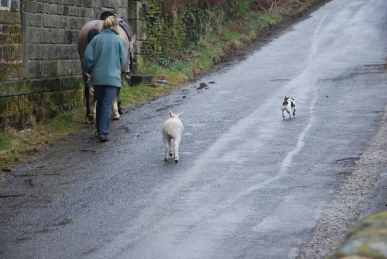 acting as an altar. Over the porch door is the coat of arms of the Bosvilles and GB 1705 carved into the stone. Graves range from the early 18th century to
  modern. Beside the church runs the old track up to the Hall. Across the fields a Curlew rises and flies up the valley emitting its haunting call. Through a kissing gate and down some old stone steps is St James’s Well. A green pool of water surrounded by stone slabs and a cast iron fence with a notice stating: “ “At Nether Midhope in the Precincts of the Manorial Homestead of Midhope-in-Waldershelf, may have been held in superstitious reverence long before Anglo-Saxon, Dane or Norman came on the scene” (Kenworthy)”. Joseph Kenworthy was a local historian. As I return to the lane, a young woman leads a horse out from the farm yard opposite accompanied by a small terrier and a lamb, whom she calls “Betsy” and it trots up the lane after them. Back in the hamlet, a small ginnel leads to “The Potter’s Well”, which was constructed of troughs said to have come from the Manorial Hall when Midhope Old Pottery was built by William Gough in 1720.
Monday 31st March – Home – March goes out like a lamb, glorious sunshine and blue skies. A Blue Tit is investigating a hole in our stone garden wall. A pair nested there last year. A Goldfinch and Greenfinch are both singing their hearts out in the Plane tree in front of the house.

Wortley – Down the road next to Wortley Hall, The Flats. Bird song rings out in the bright sunshine, particularly Chaffinches blasting out their abrupt notes from trees down the road. Primroses, Celandines and Daisies are in flower. A pair of male Blackbirds rise from a bush, twisting and fluttering furiously as they tussle with each other. Huge gnarled Poplars stand over the wall. One has lost a major limb but a new branch has grown out of the damaged area. We get as far as the park gates, one of which has been knocked off the wall, which has been damaged as well, and then head back with a wheezing Dill the Dog. We put her back in the car and then head into the grounds of Wortley Hall. The origins of the hall are unknown. Alunus de Wortley, mentioned in  the Pipe Rolls for 1165, had a residence at Wortley, which may have been on the present site. He was followed by seven successive Nicholas de Wortleys, who were Lords of the Manor of Wortley. Sir Thomas Wortley lived in a manor house in Wortley which is believed to be on this site. His grandson, Sir Richard Wortley rebuilt Wortley Hall in 1568. Sir Francis Wortley was created first baronet by James I and took sides with the King in the Civil War 1642-48. He held that a true cavalier believed “The king to be the head of the church...dares call his sovereign the anointed of god...He conceives passive obedience always due to the power of the king.” Wortley Hall was turned into a fortress and Sir Francis Wortley commanded the loyalist garrison at near by Tankersley, and led the battle on Tankersley Moor. He was captured by the Parliamentarians and taken to the Tower of London where he died in 1652. His son, also Sir Francis Wortley did not live at the hall but at St Helen’s Well near Monk Bretton. In the early 1680s, leading Sheffield artist Geoffrey Sykes was commissioned to design and paint the Salon ceiling. Sykes died, and it is said that the ceiling was completed by Sir John Poynter. Deer hunting was carried out in the park, leading to conflict with Henry Savile, Lord of Tankersley and the forced eviction of local freeholders. Records indicate this ended in about 1730 when several areas were let to tenants after the removal of the deer.
By the middle of the 18th century the hall was in a state of decay until Edward Wortley started rebuilding in 1743. Edward Wortley commissioned Giacomo Leoni, noted exponent of the Palladian style to rebuild the hall. However, the Wortleys seemed to be unaware of the methods of the style and James Archibald Stuart-Wortley-Mackenzie, 1st Baron Wharncliffe and his wife Caroline refused to move in because there was no staircase. Parts of the house were used by the American military during the Second World War.  In 1951 the house was bought by the Labour and Trade Union movement as a Workers’ Centre under the guidance of Vin Williams. It is said that in the 1960s the Earl of Wharncliffe was a jazz drummer playing in a Sheffield jazz band called the Johnnie Lennitz Quartet. The gardens are said to have been laid out by Lady Caroline. As we walk down the drive a lone Rook is calling from a nearby rookery; his fellows are scattered across the field beside the road. On the other side of this road are what looks like the old stables now converted into
  cottages. A Pied Wagtail calls from the roof of the hall. We wander around the formal gardens, which are not really much to look at as it is still early in the season. However, there are some splendid vistas of Daffodils running into the woods. The woods ring with the calls of Song Thrush, Great and Blue Tits and Chiffchaffs. Grey Squirrels are everywhere. A track leads to some fine cast iron gates leading out into the former deer park. A ha-ha runs along the bottom of the woods heading back to the house. A huge coat of arms of the Earls of Wharncliffe adorns the pediment of the house. We head back past the entrance to the walled vegetable gardens. Pheasants explode out of the garden of the cottage next to the gardens. Back in the village we call into the Countess Tearooms for a cup of tea and a slice of cake.